
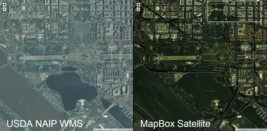
naip wms | mapbox satellite
On Tuesday, MapBox announced the release of its new Satellite layer, based partially on NAIP imagery in the US. So I said I’d like to test it for speed against the NAIP Web Map Service (WMS) hosted by USGS National Map, which I was currently using.
https://twitter.com/BrightRain/status/276000146737725440
I was initially planning to do some benchmarking on tile load speed, etc., but really, it just isn’t necessary. One zoom or pan of each will tell you that MapBox is faster, hands down.
Since what I do is highly visual — and because it’s a helluva lot more fun — I simply dropped the two maps side by side and wired up some events such that, as one side is panned or zoomed, the other is set to the same resulting extent.
Flying around in either map confirms the hypothesis: MapBox is faster.
But that wasn’t the most interesting part.
You can see that the quality is higher with higher contrast and crispier colors on the MapBox side. I did not alter saturation, hue, etc.; I left defaults on both. There’s lots more experimenting that could be done there.
Take a look for yourself and you’ll see which is faster. You’ll likely discover more interesting comparisons:
Update (2025): This little demo was built in 2012 using early Mapbox + Leaflet APIs, and the original link no longer works. I’m leaving the description here for posterity — it was a fun experiment comparing NAIP imagery speed between Mapbox and the old USGS WMS service.
https://dev.brightrain.com/naipspeed/naipspeed.html
Pro tip: Go fullscreen (F11 in Firefox or Chrome).
Hat tip: It’s centered on DC by default, for @cageyjames.
I get it — I used to be West Coast.
If you’re looking for hard numbers on tile loading speeds, sorry; I’ve got no charts. I’m sure I could rig some JavaScript to record tile load counts and timings, but this setup doesn’t lend itself to fair, rigorous benchmarking for a few reasons:
- There isn’t a map event in Leaflet that fires when all tiles are loaded.
- Map events are wired so that a slight advantage is given to the “target” map.
- MapBox Satellite also includes roads and labels — so it’s loading more (a handicap, like bowling).